


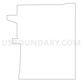
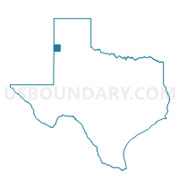
Voting District 0401, Parmer County, Texas
About
Outline
Summary
| Unique Area Identifier | 676388 |
| Name | Voting District 0401 |
| County | Parmer County |
| State | Texas |
| Area (square miles) | 170.01 |
| Land Area (square miles) | 169.20 |
| Water Area (square miles) | 0.81 |
| % of Land Area | 99.52 |
| % of Water Area | 0.48 |
| Latitude of the Internal Point | 34.42105610 |
| Longtitude of the Internal Point | -102.62313100 |
Maps

Graphs
Select a template below for downloading or customizing gragh for Voting District 0401, Parmer County, Texas


Neighbors
Neighoring Voting District (by Name) Neighboring Voting District on the Map
- Voting District 0001, Bailey County, TX
- Voting District 0003, Lamb County, TX
- Voting District 0012, Lamb County, TX
- Voting District 0101, Parmer County, TX
- Voting District 0202, Parmer County, TX
- Voting District 0206, Castro County, TX
- Voting District 0301, Castro County, TX
- Voting District 0302, Parmer County, TX
- Voting District 0303, Parmer County, TX
- Voting District 0402, Parmer County, TX
Top 10 Neighboring County Subdivision (by Population) Neighboring County Subdivision on the Map
- Muleshoe CCD, Bailey County, TX (6,745)
- Dimmitt CCD, Castro County, TX (5,824)
- Farwell-Bovina CCD, Parmer County, TX (5,301)
- Friona CCD, Parmer County, TX (4,968)
- Hart CCD, Castro County, TX (2,238)
- Earth CCD, Lamb County, TX (1,660)
Top 10 Neighboring Unified School District (by Population) Neighboring Unified School District on the Map
- Muleshoe Independent School District, TX (6,864)
- Dimmitt Independent School District, TX (5,518)
- Friona Independent School District, TX (5,085)
- Bovina Independent School District, TX (2,284)
- Springlake-Earth Independent School District, TX (1,714)
- Lazbuddie Independent School District, TX (685)
Top 10 Neighboring State Legislative District Lower Chamber (by Population) Neighboring State Legislative District Lower Chamber on the Map
Top 10 Neighboring State Legislative District Upper Chamber (by Population) Neighboring State Legislative District Upper Chamber on the Map
Top 10 Neighboring 111th Congressional District (by Population) Neighboring 111th Congressional District on the Map
Top 10 Neighboring Census Tract (by Population) Neighboring Census Tract on the Map
- Census Tract 9501, Bailey County, TX (7,165)
- Census Tract 9503, Parmer County, TX (5,301)
- Census Tract 9502, Parmer County, TX (4,968)
- Census Tract 9503, Castro County, TX (2,238)
- Census Tract 9502, Lamb County, TX (1,660)
- Census Tract 9501, Castro County, TX (1,267)
Top 10 Neighboring 5-Digit ZIP Code Tabulation Area (by Population) Neighboring 5-Digit ZIP Code Tabulation Area on the Map
- 79045, TX (19,473)
- 79347, TX (7,462)
- 79035, TX (5,309)
- 79027, TX (5,223)
- 79325, TX (2,319)
- 79009, TX (2,166)
- 79053, TX (137)